It was a sunny and hot California afternoon when I arrived at the Death Valley welcome sign. I had been driving for about 4 hours by now – coming from LA – and was feeling that mix of heat and travel exhaustion. Fortunately, after taking a few pictures, I only had a short ways further to go before my first night’s destination. A few miles after the sign, I turned off the state route onto a small dirt and sand road. My pre-trip research had encouraged me to splurge on a mid-size SUV car rental (a decision not made any easier by the covid-induced inflation of car rental prices) so for all logical reasons I would be totally fine driving down this road. But, alone and in the middle of a desert, I couldn’t help the half hour of anxiety I felt as I meandered slowly away from the pavement of the state route while praying that I wouldn’t get a flat. After parking and gearing up, I trekked about 3.5 miles into the panamint dunes, a collection of sand dunes at the northern end of Panamint Valley. I was in Death Valley National Park but not in Death Valley the valley, which meant that I was away from the majority of the tourists.
I had been wanting to visit Death Valley for the previous four years, since identifying the Cottonwood – Marble Canyon backpacking loop as a good winter hiking destination. I must have forgotten the winter component, though, because my trip ended up being in April 2022 and was, by way of perverse serendipity, during a heat wave with temperatures reaching about 100 degrees every day I was there. But, I suppose it being hot in the desert is to be expected, and the experience certainly would not have been the same had I gone in the winter.
That first night in the sand dunes was – to only slightly exaggerate – magical. It was completely isolated and the unusual surroundings could make one believe they were on another planet. After the sun set, the wind died down and everything became silent. I don’t think I’ve ever been somewhere in nature where it was so quiet – no trees creaking, no birds chirping, no waves breaking. I had only been solo backpacking once before, and so I was still a bit nervous about camping alone in the wilderness prior to this trip. But, this first night completely calmed my nerves. Unlike in the forest where one can conjure up images of monsters lurking in the trees while lying restless in the middle of the night, these sand dunes felt extremely safe and comforting. And, on top of all this, that night was completely clear and moon-less, which made for spectacular star-gazing before going to sleep.
In the morning I woke early – before the sunrise, as I was still adjusting to the time change – and hiked up to the top of the nearby dune as the sun crept over the mountains and lit up the valley. Then I packed up and hiked back to my car and drove into the true valley of Death Valley. I was leaving the much-anticipated two night Cottonwood Canyon loop for the latter half of my trip, so today I had planned just another one night excursion into the wilderness. On the internet, one person recommended a certain approach to exploring the park; parking your vehicle on the side of the road, setting a GPS waypoint on your device, and wandering into the desert with wide eyes and no plans. They said, and I can’t vouch for this, that one could stumble into a canyon unseen by another human in hundreds of years. Straying from the most-discussed hikes and destinations could allow for a remarkable opportunity to explore, in the Francis Drake sense of the word. As appealing as that sounded, I opted for the slightly more planned version, in which I found a description and GPX track for an out-and-back hike into a canyon with few reviews, meaning that it was sufficiently unpopular to make for a remote experience. The canyon was Bighorn Gorge, and I would first have to hike several miles across the open valley and then a couple miles ascending a wide rock wash before getting to the highlight of the hike, a miles-long narrow slot canyon.
For this hike, I set up my Apple Watch with a hiking app that shows a small map with your location and a GPX track, which worked incredibly well at keeping me headed in the right direction. I had considered other route-finding options, including Alltrails, Gaia, and a dedicated GPS device, but this combo – the WorkOutDoors app with a downloaded map and GPX – cost only a few dollars (no subscription needed) and was easily accessible (on my wrist) throughout the hike. On most days I’m just on the positive side of neutral when it comes to the Apple Watch, but moments like this make me really appreciate and marvel at modern technology.
Anyways, I hiked into Bighorn Gorge with the sun beating down. I didn’t realize at this point that the most interesting part of the hike was still several miles further from the entrance to the gorge, so my enthusiasm began to wane as the day wore on. Every couple miles I would take a “packs-off break” and finally I was sitting on a rock at the entrance to what seemed to be the slot canyon. With renewed energy I continued hiking only to be blocked by a dry-fall less than a minute later. I evaluated; climbing this was certainly possible but seemed sketchy with my pack on and alone. So, I took off my pack to scale the impasse and take stock of the state of the trail further along. I can’t quite remember what my plan was, but in hindsight I should have removed the top of my pack (which can function as a stand-alone fanny pack) to bring my phone, snacks, and water with me. Had I done this, I think I would have felt comfortable venturing further into the canyon, which really was quite spectacular. But, feeling somewhat exhausted and a little timid at scaling more dry-falls alone, I turned back within a quarter of a mile. Also due to exhaustion, I think, I didn’t take any pictures with my DSLR here, which I now regret. I was eager to set up camp – which superseded a desire to hike further back out of the canyon to reduce my mileage of the following day – and found a flat and soft enough spot among the rocks to pitch my tent. I read my book (the russian novel The Master and Margarita, which I was quite enjoying by this point in the trip) and waited for the sun to set behind the canyon walls. Then, a rice, beans, and tortilla dinner concluded the day.
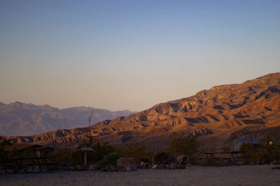
Eager to leave Bighorn Gorge behind, which by now was feeling drab and unwelcoming, I made good time hiking back to my car the next morning. I made a pit stop at Stovepipe Wells to fill up my water jugs, and then headed out the sandy road towards Cottonwood Canyon. One of the things I was looking forward to about hiking in Death Valley was the lack of reliable water sources and thus the general requirement to carry all of your water with you – that is, I was looking forward to this added challenge compared to other backpacking trips I had done. But, in this excitement, I didn’t consider that carrying a water filter with me in addition to the water itself might have been a good idea, since I might stumble upon a spring and a little extra water certainly couldn’t hurt. Nevertheless, I ventured into Cottonwood canyon with 9 liters of water and no water filter on another sunny, 100 degree day.
Another weird lapse of my brain occurred in recalling the map mileage for this first day (I thought I had 8 miles to hike before camping) and reading the map during my hike (I was deflated to read that I actually had to hike 12 miles), and then the later realization (after I had taken off my boots and rehydrated that night) that I had misread the map and the true distance was 10 miles. This inconsequential mistake only made the second half of my day more tiring, as my mental determination had been duped and required readjusting. And, to make the hike more oppressing, was the surroundings of this first section of the loop. Not dissimilar to Bighorn Gorge, I was hiking up a wide and shallow canyon that felt mockingly like a quarry. That’s not to say there wasn’t beauty here, but staring at a vista of baking sand and rock can get uninspiring after several miles.
The second day of the loop started with a nice shady walk through a long valley of cottonwood trees – whose green leaves stood out against the sandy desert backdrop. A mile or two into the day, I ran into a group of four guys playing music and enjoying the cool water from a stream. They raved to me about the source of the stream – a spring a mile further, saying that’s where they had camped the night before. They were doing the loop in the counterclockwise direction (opposite to me) and were somehow stretching it over four nights. I then found the aforementioned spring which was, true to their word, flowing quite voluminously, at least by desert standards. I rested, washed, and cooled off here, and then continued onto the bulk of the day. Mostly uneventful, it included hiking up a wide valley, over a ridge (the highest point of the loop), and into Marble Canyon. Coming up here was a point of anxiety: an 8 foot dry-fall that I would be descending. In anticipation, and to keep my mind occupied while hiking, I had been thinking of different strategies for navigating it, since the obvious method of handing off your pack to your hiking buddy was unavailable to me. The solution I came up with was to use the length of rope I had packed (an item I had luckily thrown in at the last minute but hadn’t had a planned use for) to lower my pack down, and then climb down after it. This, fortunately, worked quite well, and left me feeling somewhat victorious. I rested, read, and ate a peanut butter, jelly, and granola burrito before setting off again. I didn’t have a planned camping spot for this night, but I wanted to get far enough to make the hike out the following morning relatively short. I ended up finding a nice spot on a wide sandy ledge raised just slightly above the rocky bottom of the wide marble canyon.
Although I slept somewhat fitfully that night, I think in part to being somewhat dehydrated, I woke up surprisingly late on the third day, only being awakened by the sun cresting over the mountains. I quickly ate my oatmeal breakfast and then started off. I knew I was about to come upon the highlight of the hike, the Marble Canyon Narrows. Although shorter in length than what I had imagined (you could work through them in just a few minutes), they really were quite spectacular. I stopped at a couple locations here to take pictures, and used my tripod to take a picture of me with my pack, dwarfed by the high canyon walls. The rest of the hike out was pleasurable, mostly downhill, and marked only by the brief scare that I had to descend a large boulder impasse, before realizing that there was a path that circumvented it. Feeling proud and accomplished, I returned to my car – which was still alone in the parking lot – packed up, and drove back down that long sandy road.
See photos from the trip here.